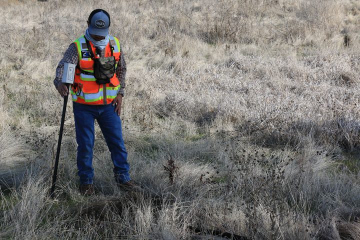
What are the responsibilities of land surveyors? If you are an investor or agent in the real estate business, you understand how vital a land surveyor is towards your field. Land surveyors help by using specialized equipment to measure property boundaries, mark them, and calculate dimensions, shapes, and elevations of public and private lands. These experts can work in different fields, ranging from construction sites, mapmaking and engineering. How important are they? To have a successful construction project, you have to depend on a land surveyor to have precise measurements of your property and have a high level of accuracy.
Land surveyors are also influential researchers who deal with property records to determine the legal boundaries, especially if under dispute. Here are the primary responsibilities of property surveyors.
They measure distances and angles on properties
You have probably heard of land disputes, with some landowners claiming their neighbors have encroached on their parcel of land. The primary duty of a land surveyor is to take measurements of lengths and angles of a piece of land to establish its boundaries legally. This process is mainly done when the landowner wants to develop their land. As stated at www.axiomgeomatics.ca, land surveyors will use special tools and equipment, ranging from measuring wheels to GPS and Geographical Information Systems to measure and gather accurate land data representing specific property boundaries, contours, and easements. In most cases, these personnel measure land which has disputes or is due for development.
They develop land survey reports and guidelines
When you are carrying out a development project in your parcel of land, you will need to incorporate the land surveyors. Why them? Land surveyors have a role and responsibility of preparing detailed reports required by government agencies, construction crews, and project managers for a specific land before construction. These reports will then be held by local land offices and used to give guidance for current and future construction projects. With their tools and mandate, the land surveyors ensure that these measurements are highly accurate and provide an accurate description and size of the piece of land in question. The report will give legal boundaries and gives the nod for future developments or the sale of the parcel of land.
Conduct a historical and legal property search
When doing their work listed above, land surveyors will rely on the previous information to perform their current land surveys. They will go deeper into historical maps, peruse the legal documents and gather all other information concerning the piece of land they want to measure before proceeding with the current measurements. They use this information with the current sizes to determine the accurate measurements and angles of the land in question. Besides this, they gather information relating to the land titles to have other helpful information concerning the land parcel.
They perform mathematical calculations
A land survey is all about mathematics to get the correct measurements of the parcel of land. Land surveyors will perform various mathematical calculations to get sizes of segments and plots of lands. The whole process involves going deeper into mathematical calculations to get accurate results free of errors and landowners and the government will use this information to determine critical decisions concerning the parcel of land in question. These mathematical results are also used in designing and coming up with structures in the allocated parcel of land. The most used mathematics are the geometrical calculations which determine the elevation and size of the land. This situation means that the land surveyor must be good at math.
They set out boundaries and reference points
When working on a piece of land, land surveyors will measure the property and, at the same time, describe its boundaries and related reference points from a starting point. They will use the records of established boundaries to mark reference points and marks, which will aid in the overall measurement and calculation processes. When they complete the measurements and calculations, the surveyor will physically mark the boundaries on the property at hand. Once a land surveyor marks the boundaries on the parcel of land, those boundaries will stay for the longest time until new measurements are done, taking the previous calculations as their base. The landowner can then use the measurements and calculations to develop their land.
Land surveyors must have technical and mathematical skills to carry out an effective and accurate land surveying process. They have to know how to take the correct measurements and do calculations as required for properties and boundaries. Their skills include mathematics, research skills, measuring skills, attention to detail, and proper communication skills. It is essential to follow these factors when choosing the right land surveyor for your piece of land to get accurate information on the processes listed above.


evora
https://www.cairoaqar.com/evora-tower-new-capital/
INNOVIEW Business Complex
https://www.cairoaqar.com/innoview-business-complex/
cairoaqar
https://www.cairoaqar.com/ray-residence-new-capital/